


Riu del Segre

elviking
User
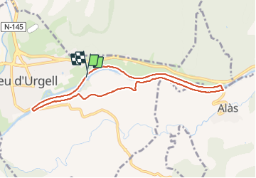

Length
8.7 km

Max alt
709 m

Uphill gradient
58 m
Km-Effort
9.4 km

Min alt
673 m

Downhill gradient
55 m
Boucle
Yes
Creation date :
2016-06-14 00:00:00.0
Updated on :
2016-06-14 00:00:00.0
1h49
Difficulty : Easy

FREE GPS app for hiking
 SityTrail
IGN / Geographical institutes
SityTrail Plus
The world is yours!
About
Trail Nordic walking of 8.7 km to be discovered at Catalonia, Lleida, la Seu d'Urgell. This trail is proposed by elviking.
Description
La seu d'Urgell - Allas
Positioning
Country:
Spain
Region :
Catalonia
Department/Province :
Lleida
Municipality :
la Seu d'Urgell
Location:
Unknown
Start:(Dec)
Start:(UTM)
374218 ; 4690673 (31T) N.
Comments